The 1965 Flood of the South Platte River
In mid-June, 1965, a series of thunderstorms of unprecedented severity and extent for Colorado resulted in the most destructive flooding in the state’s history for widespread areas from the mountains to the eastern border, including Littleton.
Floods occurred in both the Arkansas River basin and the South Platte River basin. Torrential rains on June 14-18 caused major floods on the Arkansas River and its principal tributaries from Pueblo to Great Bend, Kansas. Heavy, intense rains in three areas on three different days caused floods on many streams in the South Platte River basin from Plum Creek, just south of Denver, all the way downstream to the Colorado-Nebraska state line. The flood-producing storms followed a relatively wet period, and rainfall of up to 14 inches in a few hours was reported. The storms occurred over the Greeley-Sterling area on June 14-15, over the Plum and Cherry Creek Basins on June 16, and over the headwaters of Kiowa and Bijou Creeks (located east of Denver) on June 17. Littleton was severely impacted by the flood that originated in the Plum Creek drainage basin on Wednesday, June 16. The great South Platte River flood of 1965 was not Littleton’s first flood - it was simply the biggest and costliest, by far.
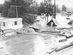
Mobile home park near Bowles and Santa Fe, during the 1965 flood. Photo by Duane Howell, Denver Post.
In 1864, just two years after the homesteading of Richard Little and his neighbors, two weeks of constant, heavy rainfall sent the Platte River out of its banks around Littleton and nearly destroyed Denver downstream. Yet another flood in 1914 lasted for six weeks, following record snowfalls the previous winter which at one time measured four feet deep on Main Street and even prevented trains from moving.
There had been talk for some time about construction of a dam on the South Platte River above Littleton, but it inspired little interest. In the South Platte River valley, Cherry Creek seemed to be the real nemesis, and that had been dammed in the mid 1930’s with the construction of Kenwood Dam which was replaced by the existing Cherry Creek Dam in 1950. The wide, shallow, slow moving South Platte River, even with the few examples above, didn’t seem to warrant the same precaution. What the South Platte River had become, instead, was a waste dump. All along its length through the Denver area it was an eyesore littered by abandoned cars, refrigerators, construction debris and everything else that people looked to discard.
Residents of Littleton and metropolitan Denver had little reason to anticipate a flood on Wednesday, June 16, 1965. The Rocky Mountain News, published for morning distribution, had the following U.S. Weather Bureau forecast in Wednesday’s paper: “Denver and Vicinity - Mostly cloudy Wednesday and Thursday: widely scattered showers and thunderstorms mostly afternoons and evenings; not much change in temperature, High Wednesday in mid 70s; low, in mid 50s.” This is not an unusual forecast for a day in June.
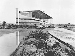
Centennial Race Track after the 1965 flood.
What caused the flooding in Littleton on Wednesday, June 16, 1965? Simply stated, the flood in Littleton was caused by extreme rainfall that fell near Castle Rock. According to a U.S. Geological Survey report on the flood, “About 2 p.m., a dense mass of clouds descended and concealed the top of Dawson Butte, 7 miles southwest of Castle Rock; and the little light remaining faded until it was dark and frightening, according to some people...,The deluge began, not only near Dawson Butte, but also at Raspberry Mountain, 6 miles to the south, near Larkspur. The rain came down harder than any rain the local residents had ever seen...,More than 14 inches of rain fell near Palmer Lake and near Larkspur in about 4 hours and over 12 inches of rain fell near Castle Rock in about the same time.” Most of this rain fell between 2 and 5 p.m. There was no unusual rainfall in the Denver metro area along the South Platte River corridor.
East Plum Creek and West Plum Creek join to form Plum Creek at Sedalia, Colorado. The U.S. Geological Survey estimated that West Plum Creek had a peak discharge of 36,800 cubic feet per second at 3 p.m. on Wednesday, June 16, at a location 4.2 miles upstream of the confluence of the two creeks. East Plum Creek had a peak discharge of 126,000 cubic feet per second at 4 p.m. at a location 5.8 miles upstream of the confluence of the two creeks. All tributaries of Plum Creek downstream from Sedalia were out of the high rainfall areas and contributed little or no runoff during the flood.
Louviers is located along Plum Creek, about five miles downstream from Sedalia, 7.5 miles upstream from the confluence of Plum Creek with the South Platte River, and about 15 miles upstream from Littleton. The U.S. Geological Survey maintained a stream gaging station at Louviers. According to their report, “The Plum Creek gaging station at Louviers was destroyed, but observations indicated that the flow increased a thousand fold, from about 150 cubic feet per second to 154,000 cubic feet per second, in less than 3 hours.” The peak discharge at Louviers occurred at 6:30 p.m.; the water started to rise sometime after 3:30 p.m.
The South Platte River upstream from its confluence with Plum Creek was not flooding but was carrying snowmelt water at about average or below average flows for June. The mean discharge for the South Platte River at Waterton on June 16 was slightly less than 1,000 cubic feet per second.
It took about four hours for the leading edge of the flood to travel the fifteen miles from Louviers to Littleton. At approximately 8:15 p.m. the leading edge of the flood arrived south of Littleton and at some time between 8:30 and 8:45 p.m. the leading crest passed through the city and into Englewood to the north. (According to a report by the City of Littleton’s Community Development director, “There were no ‘crests’ as such passing through Littleton. The width of the river and flood in Littleton was such that the crests that traveled through Sedalia became mere swells through this area.”) The U.S. Geological Survey maintained a stream gaging station on the South Platte River at Littleton. The flow increased about a hundred fold, from 1,130 cubic feet per second at 6 p.m. to the maximum discharge of about 110,000 cubic feet per second at 9 p.m. Note that the maximum discharge is more than three times larger than the 1976 Big Thompson Flood peak. From 1941 through May 1965 the largest discharge at the Littleton site was 9,720 cubic feet per second.
The U.S.G.S. also had a stream gage on the South Platte River at Denver, 0.4 miles downstream from Cherry Creek. Discharges notably began increasing at about 9:30 p.m. and reached a peak of 40,300 cubic feet per second at 1:45 a.m. on Thursday, June 17.
In general, people in Littleton and elsewhere in the Denver metro area were aware of the impending flood. An article published in the Friday, June 18, 1965 Littleton Independent reflects flood awareness in the article’s title: “Flood Sweeps Littleton River Bottoms - Town has 4 Hours to Brace for Biggest Water Destruction in Over a Century.” People had time to evacuate.
Denver radio and television stations began covering the flood in the late afternoon on June 16. In the Littleton area, “Police at first were told the flood would strike at 6:15 p.m.” (Source: Littleton Independent). The flood moved downstream much slower than some people were envisioning.
A report analyzing the warning process for the 1965 flood stated that there was a serious spectator problem. According to the Littleton Independent, “Even before the flood reached Littleton, large numbers of people gathered at the evacuation perimeter to watch the ‘disaster of the century’.... All residents west of the (railroad) tracks and east of Platte Canyon Rd. were told to evacuate at 6:30 p.m. But for every person that left the river bottom, 25 spectators moved in.... Every hillside along the valley was lined with two lanes of cars. People waited for 2 1/2 hours for the flood to strike.” Despite the large number of spectators who traveled to observe the flood, some of whom put themselves at risk, there were no flood-related fatalities in Littleton.
Along the South Platte River near Littleton, the flooding ranged in width from about 2,000 to 3,500 feet. Downtown Littleton was not flooded.
The first major damage in the Littleton area took place at the Columbine Country Club, southwest of town, where the golf course and many luxury homes were devastated. Overland Park golf course, north of town, suffered a similar fate. In Littleton, Centennial Race Track, which was within days of opening its racing season, had most of its track and stable areas inundated. A massive rescue operation by owners, trainers and jockeys saved some 140 horses. Twenty-eight thoroughbreds were lost at Centennial Race Track. (Source: Littleton’s Arapahoe Herald, Tuesday, July 6, 1965. Other sources indicated that 100 horses died.) The Littleton water system lost nine of its 15 shallow wells, putting a severe strain on the system. A network of fire hoses from the nearest Denver outlets provided emergency water for months. Outdoor lawn watering was prohibited. The flood badly damaged 26 homes in Columbine Valley, plus 80 homes and 72 trailers in Littleton.
As the flood continued north, it was more than just water bashing the countryside--it now included old cars and refrigerators and both old and new debris. This battering ram carried away or destroyed 26 bridges, including every bridge from Littleton north to the Colfax viaduct. Both Public Service Company power plants along the South Platte River were shut down and emergency circuits became waterlogged and shorted out. As the flood continued downstream, floods on other tributaries added to the flooding on the South Platte. Bijou Creek near Wiggins, for instance, had a peak discharge of 466,000 cubic feet per second. The Corps of Engineers estimated that about 238,000 acres (372 square miles) were flooded on the South Platte River, and its tributaries, through North Platte, Nebraska.
Flood damage in eastern Colorado from the June 1965 flooding totaled about $543 million in 1965 dollars. This includes combined losses in both the South Platte River Basin and the Arkansas River Basin. Much of the damage occurred in the Denver Metropolitan area. Damage estimates for Littleton could not be derived from damage values available.
The state could count itself fortunate that so few citizens were killed in one of Colorado’s worst natural disasters. In the Denver area, the flood began during the afternoon and evening hours and few people were caught without some notice. There were no flood fatalities in Littleton. Statewide, the June 1965 flooding resulted in 24 deaths. There were 11 flood-related deaths in the Arkansas River Basin and 13 flood-related deaths in the South Platte River Basin.
The 1965 flooding provided the eastern plains with relief from a three-year drought and farmers made the most out of the situation. Plans were quickly finalized and construction began on Chatfield Dam in 1967, which was completed in 1975. With a massive cleanup required all along the South Platte River, municipalities began to turn the valley into a beautiful greenbelt which today belies its garbage dump past. The river finally got its respect.
Bibliography
Armstrong, Robert E. Flood, Mud and Misery. Denver: Mountain Bell, 1965.
Colorado Legislative Council. Report to the Colorado General Assembly - 1965 Flood Disasters in Colorado. (Research Publication No. 106). November 1965.
Graham, Wayne J. June1965 Colorado Flooding - Number and Location of Deaths. April 14, 2022.
Jarrett, Robert D. and John E. Costa. 1976 Big Thompson Flood, Colorado - Thirty Years Later. (U.S.G.S. Fact Sheet FS-2006-3095). GPO, 2006.
Littleton (Colo.) Independent. Littleton Independent Publishers, 1888-
Littleton Museum. Photographic Archives.
Matthai, H. F. Floods of June 1965 in South Platte River Basin, Colorado. (U.S. Geological Survey Water-Supply Paper 1850-B). GPO, 1969.
McQuarie, Robert J. and C.W. Buchholtz. Littleton, Colorado: Settlement to Centennial. Littleton, Colorado: Littleton Historic Museum and Friends of the Library and Museum, 1990.
Rostvedt, J. O., and others. Summary of Floods in the United States During 1965. (U.S. Geological Survey Water-Supply Paper 1850-E). GPO, 1970.
Rocky Mountain News. Denver: Rocky Mountain News Publishers.
U.S. Army Corps of Engineers. Report on the Floods of June 1965 - South Platte River Basin - Colorado and Nebraska. GPO, 1967.
U.S. Department of Commerce, Weather Bureau. Climatological Data, Colorado, June 1965. (Volume 70, No. 6). GPO, 1965.
Worth, Marti F. and Benjamin F. McLuckie. Get to High Ground! The Warning Process in the Colorado Floods, June 1965. Columbus, Ohio: Disaster Research Center, Ohio State University, 1977.
Photographs courtesy of the Littleton Museum unless otherwise noted. To order copies, contact the museum at 303-795-3950.
Compiled by Pat Massengill
Extensively revised and expanded by Wayne Graham, May 2022